New, Improved “Food Desert” Map
Mar 05, 2012
 A partnership between the Johns Hopkins Center for a Livable Future and Baltimore City’s Office of Sustainability has resulted in a more comprehensive food desert definition and the release of the new 2012 Baltimore City Food Environment Map.
The new Food Environment Map was created as part of the Baltimore Food Policy Initiative to redefine “food desert” and more accurately characterize the food environment. This partnership builds upon the food desert mapping project undertaken by the Center in 2009, through the Maryland Food System Map Project; the original “food desert” map for Baltimore City was based on household income and access to supermarkets.
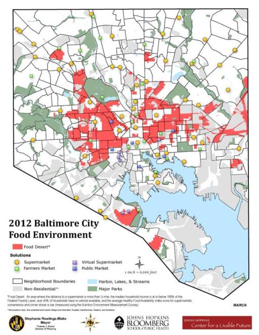
The new, more comprehensive definition of “food desert” is: “An area where the distance to a supermarket is more than one quarter of a mile; the median household income is at or below 185 percent of the Federal Poverty Level; over 40 percent of households have no vehicle available; and the average Healthy Food Availability Index score for supermarkets, convenience and corner stores is low (measured using the Nutrition Environment Measurement Survey).”
Using Geographic Information System (GIS) software, each of the criteria in the definition were mapped individually and then combined to create a final map. To qualify as a food desert, a city block had to meet all four criteria. The new food environment map shows those areas that met the food desert criteria with neighborhood boundaries and healthy food retail locations.
View the Food Environment Map and the Methodology Brief.
Food Desert Facts (Compiled by the Baltimore City Department of Planning using the 2010 Census)
- 1 in 5 people in Baltimore live in a food desert (approximately 125,000 people).
- Nearly 1 in 4 of Baltimore’s school-aged children (ages 0–17) live in a food desert (approximately 31,000 children, or 23 percent of Baltimore’s population).
- 1 in 4 of Baltimore’s African-American population lives in a food desert (approximately 105,000 people, or 26 percent of Baltimore’s African-American population).
- For other minorities, the percent of population in these areas range between 13 to 18 percent.
- Only 7 percent of Baltimore’s white population lives in a food desert.
- 1 in 3 of Baltimore’s neighborhoods contain one or more food desert areas (100 out of 278, or 36 percent of Baltimore’s neighborhoods).
Healthy Food Retail (the circles and squares on the map)
- Supermarkets: Large-format grocery stores with all food departments present, including produce, meats, seafood, canned goods, and packaged foods.
- Farmers markets: Markets with at least three vendors, open to the public. Markets are for the selling or offering for sale of fresh fruits, vegetables, juices, flowers, plants, herbs, and spices produced or grown by the vendor, and baked goods, meats, dairy goods, meats and prepared foods made by the vendor, and arts and crafts made by the vendor, occurring in a pre-designated area, including vendors that have taken such items on consignment for retail sale.
- Baltimarket: An innovative program that uses an online grocery ordering and delivery system to bring food to neighborhoods with low-vehicle ownership and inadequate access to healthy foods. It enables residents to place grocery orders at their local library, elementary school, senior/disabled housing or from any computer, and pick up their order at their community site weekly with no delivery cost.
- Public Markets: The oldest continuously operating public market system in the U.S. consists of six markets: Lexington, Northeast, Hollins, Avenue, Cross Street, and Broadway. They are open six days a week and offer a range of fresh produce and meats, as well as many prepared foods.
For more information:
Baltimore Sun Article: Baltimore Targets “Food Deserts”
Maryland Food System Map Project